About GPS Map Camera - GeoTag
If GeoTag runs properly, please, put a 5* rating and a comment with wish-features - you will help me to perfect the app! https://www.facebook.com/geotag.android/ GeoTag app was created to geotag (add exif data) the...
If GeoTag runs properly, please, put a 5* rating and a comment with wish-features - you will help me to perfect the app! https://www.facebook.com/geotag.android/
GeoTag app was created to geotag (add exif data) the smartphone photos with high accuracy (while unable to sync with DSLR cams, GeoTag can add and edit geotags to any offline images stored on your smartphone). This geotagging app allows:
- show and share your current GPS location (and show all enabled geodata - see Screen Settings to set defaults);
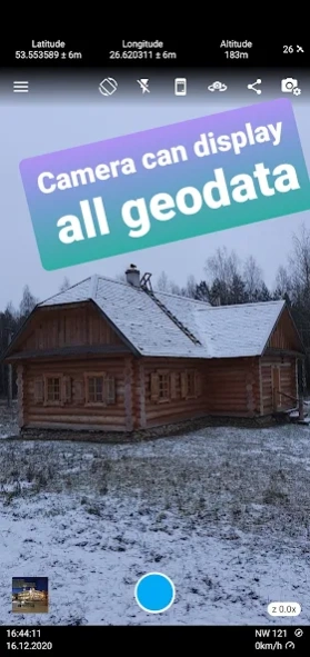
- take photos and video while displaying GPS location and accuracy on the screen,
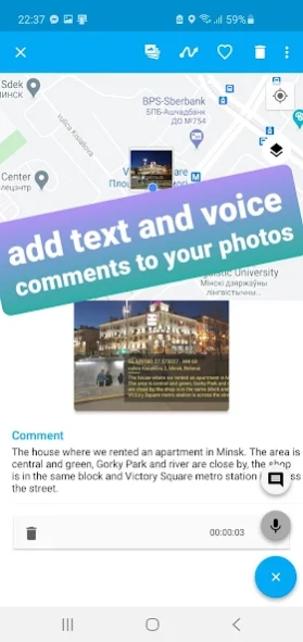
- add text and voice notes to photos (available from Image mode - tap a photo you want to edit);
- display your photos with geotags on the map (view your photos in a geoalbum);
- share photos;
- export geodata as KML, CSV or XLS files;
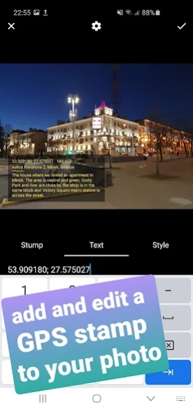
- add and edit customized geostamps / timestamps to images and videos:
- edit the GPS coordinates and other geodata of the photo, fake photo GPS.
With GeoTag you can accomplish the following:
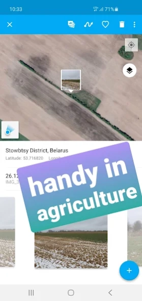
- accumulate geodata in agriculture, which is essential in farming;
- take, edit (fake) GPS data of a picture of your phone camera for private use;
- take a photo with a geotag of a fallen tree, pothole or other everyday hazard you want to report;
- geotag a car that was parked against the rules;
- in real estate: photograph a property on sale to make a PDF report and share with your friend...
Please, note that the time required to obtain GPS coordinates with your smartphone – normally 1-2 minutes - depends on weather, network coverage and other factors like nearby trees, buildings and simply being outdoors. Using the geolocation function of your device along with the camera drains the phone battery.
How GeoTag works in detail:
GeoTag can be used outdoors (using indoors reduces GPS accuracy) on smartphones that support location to take pictures with GPS exif data and share them. With GeoTag on your smartphone you can:
in Camera Mode (you enter this mode when you launch the app):
- tune the settings to be displayed on the screen (coordinates, time, address, etc.)
- take pictures while displaying real time coordinates, altitude and accuracy of your location;
- geotag pictures - save your coordinates, weather, address, date / time of taking pictures as exif;
- share your picture or geodata only (coordinates, etc.);
- jump to the last taken image to enter Image Mode
in Image Mode:
- view images, their coordinates and location on the map (maps: satellite, standard);
- swipe between images from the last taken one to view or delete them and check their map location;
- add a geostamp / timestamp to any image on any spot;
- choose Edit info to edit azimuth and other geodata;
- choose color / size / transparency of the geostamp / timestamp;
- export exif as kml file;
- add a text or voice comment (please note, that while a text comment becomes a part of the image file stored in exif data and can be shared, a voice note is not added to the file and cannot be shared along with it)
- images can be shared via Picasa, Google Drive … keeping exif data
- long-tap an image icon on map to edit location and azimuth.
in Gallery Mode:
- arrange images by name / time of creation / distance;
- choose a folder to view PDF reports;
- choose a folder on your camera to view images on the map;
- short-tap an image to enter Image Mode.
Share your ideas through Feedback section!
Previous Versions
Here you can find the changelog of GPS Map Camera - GeoTag since it was posted on our website on 2019-10-25 15:00:40.
The latest version is 2.1.1 and it was updated on 2024-04-22 11:28:22. See below the changes in each version.
GPS Map Camera - GeoTag version 2.1.1
Updated At: 2024-03-21
GPS Map Camera - GeoTag version 1.5.5
Updated At: 2023-09-07
Changes: Fixed crashes and bugs
GPS Map Camera - GeoTag version 1.4.21
Updated At: 2021-02-01
Changes: Crashes are fixed
GPS Map Camera - GeoTag version 1.4.17
Updated At: 2021-01-13
Changes: fixed bugs
added Spanish
GPS Map Camera - GeoTag version 1.4.16
Updated At: 2020-12-24
Changes: fixed bugs
updated pdf reports
GPS Map Camera - GeoTag version 1.4.15
Updated At: 2020-12-18
Changes: Fixed display of the map in the report
Fixed marker rotation on the map
Fixed bugs and crashes
GPS Map Camera - GeoTag version 1.4.14
Updated At: 2020-12-05
Changes: This version has implemented for you:
* Flexible stamp settings
* Ability to create a report in KML format
* Bugfix
GPS Map Camera - GeoTag version 1.4.5
Updated At: 2020-03-17
Changes: fixed crashes
GPS Map Camera - GeoTag version 1.4.4
Updated At: 2020-01-31
Changes: bug fixed
GPS Map Camera - GeoTag version 1.4.1
Updated At: 2020-01-13
Changes: fixed bugs
Disclaimer
Official Google Play Link
We do not host GPS Map Camera - GeoTag on our servers. We did not scan it for viruses, adware, spyware or other type of malware. This app is hosted by Google and passed their terms and conditions to be listed there. We recommend caution when installing it.
The Google Play link for GPS Map Camera - GeoTag is provided to you by apps112.com without any warranties, representations or guarantees of any kind, so access it at your own risk.
If you have questions regarding this particular app contact the publisher directly. For questions about the functionalities of apps112.com contact us.